• Home
  • Sales Tax Referendums
  • Land Protection
  • Useful Information
  • Presentations
  • Contact Us
  • More
    • Home
    • Sales Tax Referendums
    • Land Protection
    • Useful Information
    • Presentations
    • Contact Us
  • Home
  • Sales Tax Referendums
  • Land Protection
  • Useful Information
  • Presentations
  • Contact Us

Approach for Land Protection in Charleston County

In November 2025 the land conservation community analyzed all properties outside the Urban Growth Boundary (UGB) in the County to determine the amount of funds needed from a possible 2026 TST to meet the objectives of land conservation in the County.


The groups that participated in this effort were the ACE Basin Task Force, Ducks Unlimited, Edisto Island Open Land Trust, Kiawah Conservancy, Lowcountry Land Trust, Open Space Institute and The Nature Conservancy.   You can read their resulting whitepaper here.


The land conservation community’s objectives for land conservation in Charleston County are to:


  • Reduce the potential for sprawling development in the rural parts of the County, thereby lessening increases in traffic congestion and reducing the need to spend tax dollars on new and expanded roads.


  • Provide public access, especially to our waterways, thereby improving the quality of life for Charleston County residents.


  • Conserve ecologically and culturally sensitive areas, thereby protecting our unique biodiversity and rich history.


  • Provide essential flood mitigation and water purification functions, thereby protecting existing infrastructure and property equity, securing affordable drinking water, protecting fisheries, and ensuring residents recreate in clean, healthy waterways.


  • Support rural livelihoods, thereby ensuring that generational land ownership and naturally occurring affordable housing can continue for generations.

  To meet these objectives outside the UGB, a four-pronged land use approach has been used, consisting of an inner Greenbelt, an outer Greenbelt, the protection of the Sea Islands, and the protection of conservation corridors.    


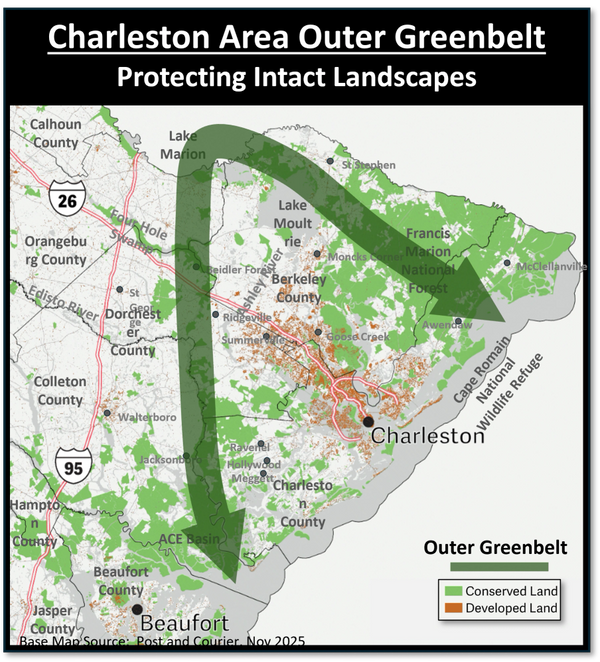
For decades, the conservation community has been developing an Outer Greenbelt around the greater Charleston region.  It is envisioned to stretch from  the ACE Basin, along the Edisto River and Four Hole Swamp to Lake Marion, and then from there to Lake Moultrie, the Francis Marion National Forest and the Cape Romain National Wildlife Refuge.


More recently, the conservation community has begun developing an Inner Greenbelt that fortifies the UGB edge through land protection.  This is especially needed on Johns Island and near the towns of Awendaw, Hollywood, Meggett and Ravenel.


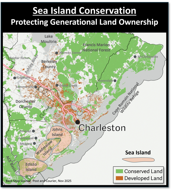
Edisto, Johns and Wadmalaw Island could each have been the next Hilton Head.  Fortunately, the land protection ethos of these communities stopped this type of development.  Even on Johns Island, which is the closest of these islands to Charleston, about 80% of the island is still rural.   But to ensure these island remain rural, the conservation community has identified them as key protection objectives.


In addition to the other conservation areas, there are conservation efforts ongoing in various corridors.  These efforts protect watersheds and viewscapes, as well as reduce urban sprawl in these corridors. 

The data above are current as of November 1, 2025.

 A Better Charleston County is a 501(c)4 organization.   

Copyright © 2025 A Better Charleston County - All Rights Reserved

  • Home
  • Sales Tax Referendums
  • Land Protection
  • Useful Information
  • Presentations
  • Contact Us